![Konza Technopolis’ Buffer Zone ‘Inter–County Physical & Land Use Development Plan [2023-2033]’](https://konzaspaces.com/wp-content/uploads/2023/03/Konza-Technopolis-and-Buffer-Zone.png "Konza Technopolis’ Buffer Zone ‘Inter–County Physical & Land Use Development Plan [2023-2033]’")
Konza Technopolis’ Buffer Zone ‘Inter–County Physical & Land Use Development Plan [2023-2033]’
The development of Konza Technopolis has led to high demand for land in the buffer zone. In so doing, this has led to among other challenges:
(i). Massive land fragmentation.
(ii). Rapid unplanned urbanization.
(iii). Uncontrolled urban sprawl.
(iv). Encroachment on eco-fragile & intrusion on protected areas.
(v). Closure of the animals’ corridors.
(vi). Depletion of agricultural zones all due to buying land for speculation.
The Inter County Joint Physical & Land Use Planning Committee – ICJPLUPC that comprises of representatives from Machakos, Makueni and Kajiado counties, has prepared the Konza Buffer Zone Inter-County Local Physical and Land Use Development Plan -2023. This plan seeks to provide a spatial development framework that will guide and control development within a 10km-radius of the Technopolis. The plan provides basic guidelines and regulation standards for general development while controlling activities for the three respective counties. It also guides developers and property owners on acceptable standards within the area.
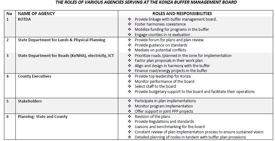
The management structure proposed for the buffer area is the Konza Buffer Management Board
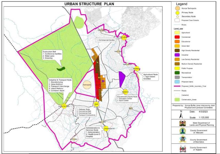
Proposed Urban Structure for The Planning Area
Among the various physical infrastructural resources considered for the buffer zone include: –
1. TRANSPORT & COMMUNICATION
ROADS – Roads in the planning area have been analyzed in terms of the international, regional and local connectivity to the Konza Technopolis buffer zone.
(a) International Roads
- Nairobi – Mombasa Highway (A8)
- Athi River-Namanga Road (A104) – This road is 135km from Athi River to Namanga on the Kenya-Tanzania border. It connects Konza Technopolis buffer zone to Tanzania.
(b) Regional Roads
- Konza – Isinya Road – This is a murram road which connects the Technopolis to Konza Trading Center. It then crosses the boundary of Machakos to Kajiado and connects to Namanga road in Isinya Trading Center in Kajiado. The road proposed for tarmacking will act as a connection to Namanga road back to Athi River then Nairobi on the North and to Boarder Post in Namanga on the South.
- Ulu Road (E411) – This road connects to Konza East Road & serves as a direct link to Ulu Railway. It is of murram standard and motorable but is impassable during rainy seasons.
- Konza East Road (E 412) – This is an earth road that connects Malili commercial node to Konza town.
- Konza Road (D 522) – This is a murram road which connects the Technopolis to Konza Trading Center. It joins Katumani road at an x-junction with A8 road which extends to connect to Katumani and Machakos town.
RAILWAY
The Standard Gauge Railway line (SGR) is located approximately 15 km from the Technopolis. It has potential for linking the Technopolis to Mombasa, Nairobi and Suswa. Konza Technopolis Development Authority (KoTDA) has been in negotiations with Kenya Railways to construct a link from the nearest SGR station at Konza station to the Technopolis. The Konza Technopolis master plan has provided for a passenger and freight station which have not been developed yet. There is also a proposed dedicated SGR link to the Technopolis from JKIA along A8 corridor. KoTDA is in Liaison with Kenya Railways Company for feasibility studies and development of the link rail.
AIR TRANSPORT
From the stakeholder engagements, there was a proposal to develop an airstrip on ILRI land in order to serve the planning area, the Technopolis and beyond. However, from the situational analysis, the plan established that the proposed site is within wildlife dispersal area, hence the proposed airstrip is likely to block or interfere with the wildlife movement pattern from Konza Technopolis (breeding grounds) – ILRI ranch – Machakos ranching – Game ranching – EPZ –Portland cement – to the Nairobi National Park. As such, the plan proposes:
(a) Adoption and implementation of the Konza Local Physical and Land Use Development Plan (2022-2032) proposal of relocating the proposed airport and flight school at Kapiti Plains to Konza Technopolis. This will attract global investors in the Technopolis and beyond as well as providing alternate landing for JKIA.
(b) The buffer zone to utilize the existing air transport facility such as JKIA with consideration for extension of Nairobi-Mombasa express way from JKIA to the Technopolis. Carrying out of a feasibility study for an alternative airstrip(s) within the buffer zone.
TELECOMMUNICATION
(a) Internet – There are four fibre optic cables passing along the eastern boundary of the Technopolis. The cables link Nairobi to Mombasa, which serves as a hub for international sub marine cables TEAMS (The East African Marine System); SEACOM (South East Asian Communication); EASS (East Africa Submarine System) and The Kenya Data Network-Reliance cable.
(b) Telephone – The area enjoys coverage from local mobile phone service providers Safaricom, Airtel and Telecom.
2. WATER SUPPLY
Konza Technopolis buffer zone is located within the Athi Basin, whose water resources are managed by the Tana Athi Water Services Board. The region is arid & semi-arid land (ASAL). There are two permanent rivers; Athi River and Tana River which form the far eastern boundary. There are also high yielding springs notably Nol Turesh which is located at the eastern base of Mt Kilimanjaro and whose flow is tapped for Machakos, Kajiado, Athi River towns and surrounding consumers.
(a) Nol- Turesh Pipeline
The buffer area is traversed by one main water pipeline system, the Nol-Turesh water supply from Mt. Kilimanjaro that serves various areas of the three Counties (Machakos, Kajiado and Makueni). A water line from the springs was commissioned in 1990. Currently, the water supply system is abstracting Nol-Turesh Corridor- 23,443 m3 and Loitokitok Corridor – 2,000 m3 of water per day.
(b) Oloitokitok Water And Sewerage Company
KoTDA has established the availability of Oloitokitok Town Water Supply to supply the Technopolis as a second source of water alongside Nol Turesh springs. The water company comprises two pumping stations with a capacity of 125m3 /hr., pumping head of 172m, and power requirements of 132kw for each of the pump sets. The water is stored in a masonry storage tank (500m3) at Loitoktok town for distribution by gravity. There is also a masonry storage tank of 200m3 capacity at the intermediate pumping station. This enables temporary storage of water before pumping to the Loitoktok tank.
(c) Dams
- Thwake Dam – It’s being built on Athi River to be a multipurpose dam that will provide drinking water, irrigation water, hydropower, and other water supply infrastructure. The water storage reservoir is 681 million cubic meters and is meant for rural homes, Konza Technopolis and other local areas. It is being developed for long-term water supply to Konza Technopolis, with a capacity of 100,320 M3/day of treated water. Construction of Phase I work is 80% done. It comprises a dam, intake tower, spillways, and associated civil engineering works and two hydro-mechanical works, water supply schemes are proposed to be supplied from Thwake Dam. Available documents indicate the dam will be done in 2027.
- Proposed ILRI Dam- Konza Technopolis development authority is collaborating with ILRI in constructing a dam to collect rainwater channeled from the Technopolis.
3. ENERGY
(a) Electricity – A power gridline of 132 kV transmission lines passes through Technopolis buffer zone. A 132/33 kV Konza power substation and 132 kV transmission line has been constructed north of Konza (Mombasa Road and Konza Road) serving the initial power demands for the Technopolis and the buffer zone. A 400 KV line to Mombasa from Suswa through Nairobi passes through Isinya, 40 Km away from the Technopolis. Consequently, construction of a 40-kilometre 400kV Konza-Isinya power line was launched in 2019. This will ensure a steady supply of power for the Technopolis as well as Makueni and Machakos Counties. Currently a 400KV power substation is under construction at the Technopolis. This will supply power to the buffer zone as well.
(b) Renewable Energy – The Konza Technopolis buffer zone has potential for renewable energy generation. A 58- acre piece of land has been planned at Konza Technopolis to produce 5MVA of power for the Technopolis. The area has excellent sites such as hill tops for tapping of alternative sources of green energy like wind and solar power. Biogas can also be generated in the ranches and farms.
4. SEWERAGE
The buffer area has no sewerage system because it was generally a green field. The main method of wastewater disposal is by pit latrines. Soak pits are also used in the urban node of Malili but their use is challenged by inadequate water. Konza Technopolis has a Water Reclamation Facility developed to reclaim all wastewater and treat it to WHO portable standards. 75% of the recycled water will be used within the Technopolis while 25% will be deposited in the nearby stream exiting to the buffer zone area.
5. SOLID WASTE DISPOSAL
There are no designated waste disposal sites and hence solid waste management in the buffer area is very poor. However, a vacuum solid waste system has been developed for phase 1 of the Konza Technopolis including a handling facility; additionally, two more waste handling facilities have been planned at the Technopolis. This will handle waste collected in four fractions that are separated at the source. Use of appropriate technologies, such as waste minimization, to safeguard the environment through “Reduce-Reuse-Recycle (RRR)” approach may be adopted.
